Scenic Trail Interpretive Center/ Suspension Bridge

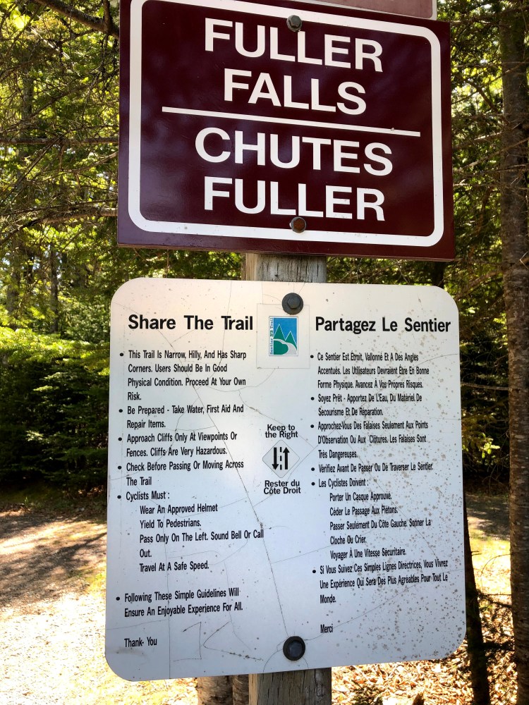
After leaving Fuller Falls we stopped at the park Interpretive Center and watched a video about the local lumber industry. Lumbering at that site was prevalent from 1850 to 1950. The logs were cut high on the hills surrounding the Salmon river, rolled down to the river in the spring and floated down to the Bay of Fundy to awaiting ships. The lumberjacks had to cut 90 trees per day.

A suspension bridge was a short walk away and we crossed over to the other side. In the middle of the river we saw a strange barrel shaped piece of equipment which was rotating as the river flowed through it.  We learned from the Park Ranger that it was a gadget to count Salmon as they swam down river. This part of the river was known as the “ Honey Hole” for catching Salmon.

img_4435

img_5975

Caves on the Fundy Trail Scenic Drive

Southeast of Saint John lies the fishing village of St Martins located on the Bay of Fundy. It was low tide when we arrived and Nancy and I walked on the ocean floor exploring the huge caves located there. It’s hard to fathom the ocean rolling back far enough to expose several hundred yards of dry sand, mud and rock but it happens. We enjoyed frolicking where the waves roll. We met a nice couple from Montreal making sand sculptures in one of the caves.  Listen to the video as they introduce themselves.

In one canyon a rope hung down from above to be used as an emergency escape method.  I climbed a short distance straight up! On our return from the Scenic drive we stopped at the caves during high tide. The ocean had reclaimed its rightful place. No walking to the caves now.  We watched people kayak into the caves that we had walked into just hours before.

img_5877

img_5908img_5909

img_5928img_5930img_5933img_5935img_5937

img_5949


Reversing Falls Saint John NB

Just west of Saint John we stopped at an information center and were greeted by Larry who shared area information with us. You can’t see the Bay of Fundy sites without knowing the tide schedule. We were just in time to get to the campsite set up and see the reversing  falls at high tide. The St John river meets the bay of Fundy at Saint John. When the tide comes in the water actually moves upstream with the force of the tide. As we learned from Larry, the tide actually starts in the Indian Ocean and moves up to the Bay of Fundy, forcing water to back up the Saint John river 80 KM! We drove to the overlook and marveled at what we saw.

img_5861img_5864

img_5868

Canadian Border Crossing

We finally made it to the border crossing at Calais (pronounced Calus).  We tried to anticipate everything as we expected to be stopped and searched. After Nancy researched the Canadian web site for the do’s and don’ts, we left in Michigan all things illegal in Canada. We were ready to be searched but luckily we weren’t.  The Canadian border guard must have liked my answers because after about six questions he waived us through without searching for any contraband. Once into Canada we drove about an hour to St John New Brunswick ( NB) where we stayed for three nights.

img_4401img_4403img_4405img_4407

Sunset on our last day in Maine (June 8)

We really enjoyed our time in the Acadia National Park. Sightseeing, hiking, biking and great seafood can easily be found. Nancy and I caught the sunset looking at the Bass Harbor Head Lighthouse and finished off the sunset while enjoying a piece of blueberry pie at the Seafood Ketch restaurant. We had near perfect weather during our stay and visiting during the first part of June beat the after school crowds.

img_5840img_5842img_4369img_5850img_5851img_4394


Watching the Sunset


We joined the crew on the four masted Schooner Margaret Todd last evening for a sunset sail. The seas were calm when we left the dock and the boat charted a course for the Porcupine Islands a short distance out in the bay.  Once past the other boats in the Harbor the sails have to be raised. The captain asked for volunteers to haul on the ropes. Without thinking I jumped up and went to one of the positions with three other people.  Our crew hauled on the line and the 1000 square foot sail slowly ran up the mast.  My shoulders ached when finished and I was glad that others volunteered to raise the next sail. With the sails set we continued on our journey.

While sailing we enjoyed the music of “ Florida Keyes Dan”, a 30 plus year veteran musician who played 60’s era folk and light rock songs.  Towards the end of the evening he handed out tambourines, maracas, and other “noise makers”  and we all made music. What a hoot! We were blessed with a great sunset and a wonderful time was had by all.  Nancy asked a young boy how he liked the trip and he said “it was the best day ever!”. We certainly agreed.

img_4278

img_5733img_5735-1img_5736img_4287-1img_4286

img_5766img_5770img_5769-1

img_4323-1

img_5745

img_4324img_5769img_5768

img_5767img_5776img_4321-1img_5743img_5777

img_5764

Thunder Hole

One of the must see stops on the park loop is Thunder Hole.  The hole is a 5 foot wide 100 foot long slit in the granite ending in a small cave.  When the waves come in the water builds into a crescendo of water spray and sound.  It was fun trying to time the camera shot with the wave action.

Acadia National Park

We meandered our way up the coast and arrived at Bar Harbor. After finding a parking spot we visited the tourist and National Park info center.  We have found it best to start at the info centers to find the best hikes and other must see attractions.  We also asked for restaurant suggestions.  While they aren’t supposed to make recommendations, we were told where they ate yesterday.  That was good enough for us. We had a great lunch at “The Stadium”, where we each enjoyed a bowl of clam chowder and split a lobster roll.  The food was excellent and the education about lobsters was almost as good.

Armed with lots of information we traveled the Park Loop Road stopping first at Sand Beach.

More tomorrow…….